Thursday, April 9, 2009
8th April 2009
Today we revisited the factors which affected the hydrographs as well as went through the answers for the exercise given to us(pg 231 of text). We also learnt more about various factors such as shape of basin and how it affected the hydrographs and more about drainage density.This is mainly what we went through for the answers in the activity:
1. Lag time
2. Shapes of basin affecting shape of hydrograph
3. Drainage density and how it affects hydrographs
4. Effects of vegetation and urbanization on hydrographs
So what is a drainage basin? For those who did not know yet, it’s actually like the idea of funnels, the imaginary area where rainwater collects or drains into.
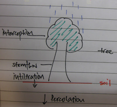
“Lag time” is defined as the time between peak rainfall and peak discharge. Another explanation could be the time taken for the river to react to rainfall.Lag time happens because of processes like interception, stem flow, infiltration as well as percolation which affect the movement of water (see picture below).Therefore, the water will take time to flow and reach the mouth of the drainage basin, going through other processes such as base flow to reach the drainage basin.
(Baseflow – defined as the basic amount of water flowing through the river when there is no rainfall.)
Link between lag time and likelihood of flooding:
With a shorter lag time, the more the runoff, if the water level is higher than bankful discharge, it would mean that flooding will occur.
For example, look at these 2 rivers. Note that the amount of rainfall is the same.
River A (Shorter lag time)
There is a lot of runoff(overland flow) in river A, thus causing the water level to raise above bankful discharge.
River B (Longer lag time)

In river B, factors such as bigger surface area, increase in interception, infiltration and percolation, thus the water will take a longer time to flow. With a longer time to flow, there is lesser runoff, thus the amount of water does not exceed it’s bankful discharge.
(Bankful discharge: Maximum amount of water that can flow in a river without over flowing it’s banks)
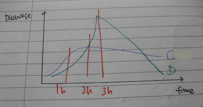
Secondly, we discussed about the shape of the basins and how the shape affected the shape of the hydrograph (pg 230)
Drainage basin C Vs Drainage basin D ( long vs round drainage basin)
Drainage basin C

Drainage basin D

Graph Between drainage basin C and D

We also discussed how different shapes affected the graphs, how much water and how long the water will take to reach the mouth of the basin.
a)
b)
[The numbers represent the water flow, and 1 comes first as it is nearer to the mouth of the drainage basin. The arrows show the different distances the water has to flow before reaching the mouth of the basin and how much water there is, thus affecting the shape of the graphs.]
Thirdly, drainage density.
The higher the drainage density, the more rivers, which would mean more surface runoff (When water falls as rain, it directly falls into the rivers, going straight to the mouth of the drainage basin.)
Drainage Basin A (Lower drainage density)
- Graph tends to be gentler
Drainage Basin B (Higher drainage density)

- Graph tends to be steeper
Lastly, moving on to the effects of vegetation and urbanization.
- Vegetation -> increase in interception -> increase of infiltration -> increase of ground water. Therefore longer lag time, less steep rising and falling limb of hydrograph.
- Urbanisation -> decrease of infiltration -> increase of runoff -> decrease of ground water. Therefore shorter lag time, steeper rising and falling limb of hydrograph.
Yup, That’s all folks!
Darren.


